Rexburg Urban Renewal Districts
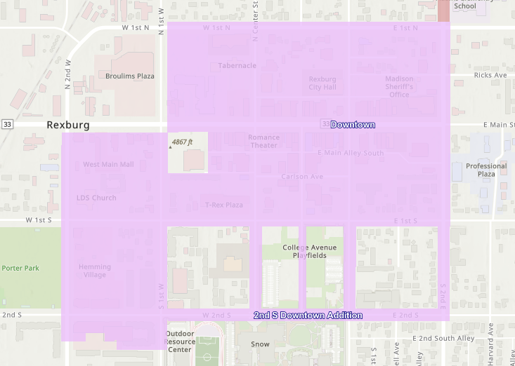
Downtown District
Created Date – 1/1/2003 | Last Tax Year – 2027
The 3rd district was originally formed downtown and included 7 city blocks bordered by 2nd West, 2nd East, 1st North, and 1st South. The 2003 Downtown District was put in place to combat problems of physical deterioration and economic underdevelopment in the seven block area, to make public improvements, and create public facilities. Key elements of the plan include initiating simultaneous projects designed to revitalize the project area, secure certain public open space in critical areas, develop new mixed-use development projects, pursue development across all land-use sectors, and develop parking facilities. In 2014 the Agency extended the Downtown district one block further from 1st South to 2nd South. (Indicated in green on the map.) The area has a history of a slow growing tax base primarily attributed to inadequate and deteriorating public improvements and other deteriorating factors.
Proposed Redevelopment Actions
The Agency proposes to eliminate and prevent deterioration and the spread of deteriorating conditions in the Project Area by:
Acquisition of certain real property (if needed) and through the voluntary measures described in Section 305;
Demolition or removal of certain buildings and improvements for public rights• of-way for streets, utilities, walkways, and other improvements for public facility building sites, to eliminate unhealthful, unsanitary, or unsafe conditions, improve density, eliminate obsolete or other uses detrimental to the public welfare, or otherwise to remove or to prevent the spread of deteriorating or deteriorated conditions;
Provision for participation by property owners within the Project Area to achieve the objectives of this Plan;
Management of any property acquired by and under the ownership and control of the Agency;
Provision for relocation assistance to displaced Project Area occupants, as required by law;
The installation, construction, or reconstruction of streets, railroad spurs (as allowed by law), utilities, including electrical distribution and transmission lines in underground configuration, if needed to encourage new developments, fiber optic or other communication systems, parking facilities, and other public improvements, including, but not limited to, irrigation and drainage laterals and ditches, canal crossings, storm drain systems, water and sewer improvements, fire protection systems, streetlights, traffic signals, sidewalks, curbs, gutters, and other public improvements, including community facilities owned or occupied by the Agency or other public agencies, including the City’s walkways, public open spaces, community centers, cultural centers and visitors or information centers as may be deemed appropriate by the Board, and also including other public improvements, such as, but not limited to, installation, construction or reconstruction of fire stations and/or police stations;
Disposition of property for uses in accordance with this Plan;
The redevelopment of land by private enterprise or public agencies for uses in accordance with this Plan;
Rehabilitation of structures and improvements by present owners, their successors, and the Agency;
Preparation and assembly of adequate sites for the development and construction of facilities for commercial, public, mixed-use development, office, appropriate retail, and other ancillary uses;
As allowed by law, lend or invest federal funds to facilitate redevelopment;
Construction of foundations, platforms, and other like structural forms necessary for the provision or utilization of air rights, sites for buildings to be used for residential, public, commercial, and other uses contemplated by the Plan, and to provide utilities to the development site; and
Coordinating with the City in the implementation of the City’s Comprehensive Plan within the Project Area In the accomplishment of these purposes and activities and in the implementation and the furtherance of this Plan, the Agency is authorized to use all the powers provided in this Plan and all the powers now or hereafter permitted by law. The Agency intends to encourage development of a mixed-use project consisting of governmental, residential, office, and supporting commercial and retail. For purposes of this Plan, the reference to “Mixed-Use Development” shall mean this objective.
In the accomplishment of these purposes and activities and in the implementation and furtherance of this Plan, the Agency is authorized to use all the powers provided in this Plan and all the powers now or hereafter permitted by law. The Agency intends to encourage development of a mixed-use project consisting of residential, office, and supporting commercial and retail. For purposes of this Plan, the reference to “mixed-use” development shall mean this objective.
Objectives
Urban renewal action is necessary in the Project Area to combat problems of physical deterioration or deteriorating conditions.
The Project Area consists of the original approximately seven (7) city blocks bordered by 2nd West on the west, 2nd East on the east, 1st North on the north, and 1st South on the south. The 2009 amendment added the West 2nd South Area Hemming Site that included the area of West 1st South on the north, South 1st West on the east, properties on West 2nd South on the south, and South 2nd West on the west. The East 2nd South Area includes the following public street rights-of way:
East 2nd South Street from South 1st West Street to South 2nd East Street;
South Center Street from East 1st South Street to East 2nd South Street;
College Avenue from East 18′ South Street to East 2nd South Street;
South 1st East Street from East 181 South Street to East 2nd South Street;
Princeton Court; and
South 2nd East from East 1st South Street to East 2nd South Street.
The area has a history of a slow-growing tax base primarily attributed to inadequate and deteriorating public improvements and facilities, poorly maintained properties, undeveloped and underdeveloped properties, diverse property ownership, parcel site and configuration, and other deteriorating factors. Hence, the Plan for the Project Area is a proposal for street and utility improvements to provide an improved environment for new commercial, residential, public and Mixed-Use Development developments; eliminate unsafe conditions; assist potential owner participation and other developers to create appropriate development sites through parcelization of existing larger parcels and, where necessary, through acquisition, demolition, and disposition activities; and otherwise prevent the extension of deterioration and reverse the deteriorating action of the area.
Any streets or other rights-of-way to be vacated or relocated will create additional building area for Mixed-Use Development or public use. Vacations or relocations must be requested from the City or any agency having jurisdiction over the particular public right-of-way.
Air rights and subterranean rights may be disposed of for any permitted use within the Project Area boundaries.
Less than fee acquisition may be utilized by the Agency when and if necessary to promote redevelopment in accordance with the objectives of the Plan.
The Agency may act to improve transportation opportunities throughout the Project Area.
The Agency may participate in the cost of removal of extraordinary site conditions. A further objective of the Plan is to provide for the acquisition and clearance of property to be used for other public facilities. Off-street parking facilities may be developed to serve new commercial uses within the Project Area. Finally, an objective of the Plan is to provide for installation, construction or reconstruction of public facilities or buildings, including but not limited to fire stations and/or police stations. Over the life of the Plan, land use in the Project Area will be modified to the extent that buildings currently vacant and land underdeveloped may be converted to Mixed-Use Development, public and private parking, and public/semi-public uses.
The provisions of this Plan are applicable to all public and private property in the Project Area. The provisions of the Plan shall be interpreted and applied as objectives and goals, recognizing the need for flexibility in interpretation and implementation, while at the same time not in any way abdicating the rights and privileges of the property owners which are vested in the present and fame zoning classifications of the properties. All development under an owner participation agreement shall conform to those standards specified in Section 303.1 of this Plan.
This Plan must be practical in order to succeed. Particular attention has been paid to how it can be implemented, given the changing nature of market conditions. Transforming the Project Area into a vital, thriving part of the community requires an assertive strategy.
The following list represents the key elements of the Plan:
Initiate simultaneous projects designed to revitalize the Project Area. From street and utility improvements to significant new development, the Agency plans a key role in creating the necessary momentum to get and keep things going.
Secure certain public open space in critical areas (e.g., plazas and pathways); this public open space will greatly increase property values adjacent to it and greatly contribute simultaneously to a new sense of place.
Develop new Mixed-use Development projects.
Pursue development across all land-use sectors.
Develop parking facilities.
Install, construct, or reconstruct public facilities or buildings, including but not limited to fire stations and/or police stations.
Without Agency intervention, much of the Project Area could remain unchanged through the remaining term of the Plan. It is anticipated success will come through numerous public-private partnerships. The Plan creates the necessary flexible framework for the Project Area to support the City’s economic development.