Rexburg Urban Renewal Districts
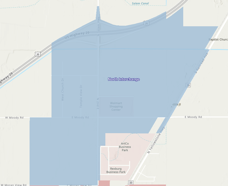
North Interchange District
Created Date – 1/1/2015 | Last Tax Year – 2035
North Interchange District Plan
The 5th development area was established in 2015, known as the North Interchange District.
Proposed Redevelopment Actions
The Agency proposes promote economic development around the Walmart development by:
The acquisition of certain real property (if needed);
The management of any property acquired by and under the ownership and control of the Agency;
The disposition of property for uses in accordance with this Plan;
The redevelopment of land by private enterprise or public agencies for uses in accordance with this Plan;
The preparation and assembly of adequate sites for the development and construction of facilities for industrial, commercial, residential, retail, and governmental use;
Objectives
The Project Area and revenue allocation area consist of approximately [679] acres of property, including parcels currently located outside the City limits and within the boundaries of Madison County and parcels located within the boundaries of the City of Sugar City. Those properties that remain outside the City of Rexburg city limits will be governed by a negotiated intergovernmental agreement between the City and Madison County, and the City and, Sugar City. The Project Area boundaries are specifically identified on the attached map. The Project Area has a history of a slow-growing tax base primarily attributed to undeveloped or underdeveloped properties, deteriorated and vacant lots, faulty lot layout, lack of adequate public infrastructure, potential environmental issues and other deteriorating factors.
Site preparation, remediation of any environmental issues, enhancement of open areas and public recreation facilities, enhancement of infrastructure, including roadways, intersections and interchanges, sidewalk, curb, gutter, improvements to water and sewer facilities, as well as, remediating any drainage issues will enhance the overall development of the Project Area.
Hence, the Plan for the Project Area is primarily a proposal for street and utility improvements to provide an improved environment for new retail, residential and commercial facilities, public improvements or facilities, the elimination of unsafe conditions, and to otherwise prevent the extension of deterioration and reverse the deteriorating action of the area.
Temporary project improvements shall be provided to facilitate adequate vehicular and pedestrian circulation.
The provisions of this Plan are applicable to all public and private property in the Project Area. The provisions of the Plan shall be interpreted and applied as objectives and goals, recognizing the need for flexibility in interpretation and implementation, while at the same time not in any way abdicating the rights and privileges of the property owners which are vested in the present and future zoning classifications of the properties. All development under an owner participation agreement shall conform to those standards specified in Section 303.1 of this Plan.
This Plan must be practical in order to succeed. Particular attention has been paid to how it can be implemented, given the changing nature of market conditions. Transforming the Project Area into a vital, thriving part of the community requires an assertive strategy. The following list represents the key elements of that effort:
Initiate simultaneous projects designed to revitalize the Project Area. From street and utility improvements to significant new development, the Agency plays a key role in creating the necessary momentum to get and keep things going.
Develop new commercial opportunities and encourage economic development.
Pursue development across all land-use sectors.
Without direct public intervention, much of the Project Area could conceivably remain unchanged for the next several years. It is anticipated success will come through at least one public-private partnership. The Plan creates the necessary flexible framework for the Project Area to support the City’s economic development.
Land use in the Project Area will be modified to the extent that buildings currently vacant and land now devoted to scattered inconsistent uses will be convened to professional offices, residential housing, commercial, public and private parking, and/or public/semi-public uses. In implementing the activities described in this Plan, the Agency shall give due consideration to the provision of adequate park and recreational areas and facilities that may be desirable for neighborhood improvement, with special consideration for the health, safety and welfare of residents in the general vicinity of the site covered by the Plan.